Met Office reveals exactly when 'disruptive snow' could hit Greater Manchester
Snow could start falling in Greater Manchester from tonight, according to Met Office forecasters.
Parts of the UK, including our region, are braced for 'disruptive snow' over the coming days as temperatures plummet. Up to 20cm of snow may accumulate in the worst affected areas in the country’s 'first taste of winter', the Met Office has said.
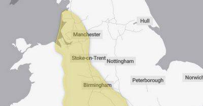
A 15-hour yellow weather warning for snow and ice is set to come into force at 7pm tonight (Monday) and will last until 10am tomorrow. It covers all of Greater Manchester, as well as parts of the East Midlands, the North East, Scotland, Wales, the West Midlands, Yorkshire and Humber and other parts of the North West.
READ NEXT: Met Office warns of 'disruptive snow' as UK braces for 'first taste of winter'
Explaining the warning, the Met Office said; "A period of rain, sleet and snow will occur during Monday evening, overnight into Tuesday morning. The most likely scenario is for most of the snow to accumulate on hills, with 5 to 10 cm possible above 200 metres and perhaps as much as 15 to 20 cm above 300 metres.
"There is a small chance of snow settling at lower levels, where 5 to 10 cm would prove much more disruptive, but this remains very uncertain. As rain, sleet and snow clear on Tuesday morning, ice may form on untreated surfaces."
For Greater Manchester, a Met Office weather map shows that the white stuff could begin to fall over parts of our region from around 8pm. The precipitation chart shows the snow patch over our region through much of the evening and overnight into Tuesday, with it clearing by around 7.45am tomorrow morning.
Forecasters predict the snow over our region may be more like 'sleet', though it is still expected to cause disruption overnight and into
Related News