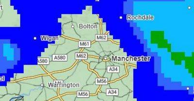
Met Office weather map shows where snow will fall in Greater Manchester over next 24 hours
Parts of Greater Manchester could see some snowfall tonight, according to the latest weather map from the Met Office.
The region is set to see patchy showers across the afternoon, with some areas possibly seeing hail showers too.
From around 8pm snow is set to fall over the Peak District and parts of Lancashire, then by 10.30pm snow is expected over Rochdale, with other parts of the region seeing more rain and hail.
READ MORE: Two flood alerts issued in Greater Manchester with more heavy rain forecast
Try MEN Premium now for FREE... just click here to give it a go.
Further patches of snow are expected across Wigan and Bolton as the night goes on, with the worst-hit areas looking likely to be higher ground in Rochdale and Oldham. The south of the region is expected to remain dryer, with some patches of rain and hail.
The Met Office forecast for Oldham predicts showers this afternoon before a 40 per cent chance of light snow between 8pm and 10pm tonight, and a further chance of some sleet and light snow on Friday morning from 6am. Temperatures could drop to just 1C by 2am, but could feel as cold as -4C as the night goes on.
In Rochdale, showers are forecast between 6pm and 11pm before a cloudy rest of the night. There is a further chance of rain from 3am and then a 60 per cent chance of sleet between 5am and 7am. The forecast for Littleborough shows a 90 per cent chance of heavy snow from 5am. Overnight temperatures in the borough are expected to be around 2C.
Tameside could also see some flurries with the forecast predicting light snow and sleet from around 4am.
While the snow over Greater Manchester looks set to clear by the middle of the morning, rain and hail showers are expected to continue throughout
Related News