Met Office forecast shows all UK areas where snow will fall in hours
After a few weeks of milder weather following the snow, ice and sub-zero temperatures of early January, the UK is bracing for another round of winter as we head towards the weekend. As early as Thursday evening (January 30) parts of the UK are set to see the return of snow and icy conditions.
The latest Met Office maps show a band of wintry weather sweeping across the UK from the west, with the western parts of Scotland predicted to see snowfall around 9pm on Thursday. At around the same time, the weather front will see rain and hail hitting most of Northern Ireland as it continues to move east.
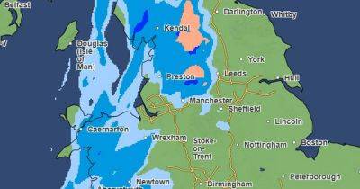
The snow will continue to spread throughout the Scottish Highlands as the evening goes on, with parts of Cumbria and the north Pennines likely to see snowfall by around 11pm. This wintry weather will continue east across the country with snow expected in the Yorkshire Dales by around 1am on Friday (January 31).
In Greater Manchester, the latest maps also predict snow flurries in some parts of the region early on Friday morning (January 31). However, more wintry conditions and snowfall are anticipated in the northern and eastern parts of Greater Manchester.
The latest Met Office maps indicate snow flurries on higher ground north of Bolton and Rochdale from 1.30am. By 2am, snow is forecast to be more widespread, covering areas near Oldham and Tameside, extending into the Peak District. These conditions are expected to persist for several hours, while heavy rain will fall on the rest of Greater Manchester.
The wintry showers are predicted to ease across the UK by around 7am and throughout the morning. However, the Met Office warns it will remain cloudy, with potential drizzly outbreaks around hilly areas in the afternoon.
Related News