Is Storm Éowyn a hurricane? The science behind ‘bomb cyclone’ bringing record winds to UK
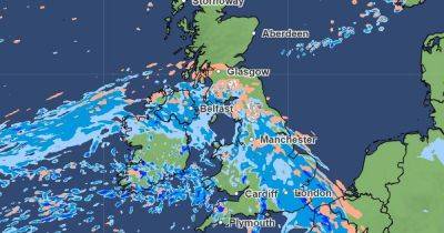
Storm Éowyn has brought hurricane-force winds to parts of the UK and Ireland today.
Forecasters warn the explosive ‘bomb cyclone’ will bring deadly winds, heavy rain and snow, marking the worst storm of the season so far.
The Met Office has issued rare red weather warnings across Northern Ireland and Scotland, with much of the UK issued with amber warnings as widespread disruption is expected.
A wind speed of 114mph brought by Storm Éowyn has been recorded in Ireland, the fastest since records began, forecaster Met Eireann said.
This exceeds the previous record set in 1961 during Hurricane Debbie, with forecasters warning Storm Éowyn could be the ‘storm of the century’.
With hurricane-force winds expected across the UK, what makes Storm Éowyn different from a hurricane?
A hurricane is a tropical cyclone, otherwise known as a typhoon, explains Professor Liz Bentley, Chief Executive at Royal Meteorological Society.
“They form over tropical oceans where there is heat and moisture that help drive the development of the system. They usually start as a small cluster of thunderstorms and, if the conditions are right, a flow of very warm, moist air rises rapidly leading to the development of a low pressure system or tropical cyclone,” Prof Bentley told the M.E.N.
Hurricanes are classified based on the strength of its wind. If wind speeds exceed 73mph for an extended period, it is categorised as a hurricane.
Storm Eowyn is caused by a band of strong winds at the top of the atmosphere called the jetstream. The stream blows from west to east, directing storms across the Atlantic to the UK.
Despite having sustained wind speeds of over 73mph – classed as ‘hurricane-force winds’ – it is not a hurricane. Instead, it is what