Greater Manchester hour-by-hour snow forecast for each borough
Greater Manchester is experiencing disruption across the region due to more wintry weather - with schools and major roads closed.
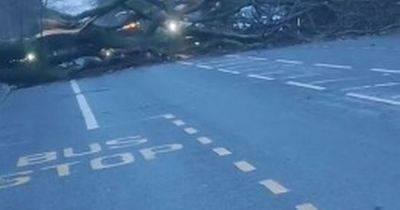
There was heavy snow over the weekend which was followed with rain and freezing temperatures, causing disruption this morning (January 6).
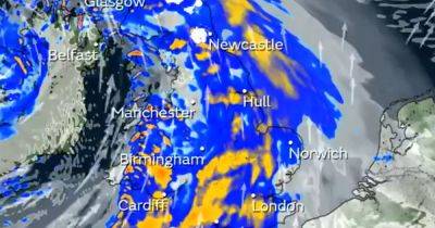
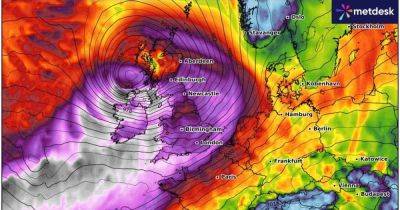
Two Met Office weather warnings remain in force across the region for heavy rain, and snow and ice, as well as several flood alerts. Now, a new weather warning for snow and ice has been issued by the Met Office.
The warning covers most of the North West, Wales, the South West and parts of the Midlands. It comes into force at 5pm today and lasts until 10am on Tuesday.
Forecasters say sleet and snow showers will develop tonight, leading to icy stretches. They warn that roads and railways are likely to be disrupted, while pedestrians and cyclists will need to take care on untreated roads and pavements.
This disruptive weather comes as parts of Greater Manchester are still recovering from floods over New Year. Manchester Airport closed its runways this morning following snow, before reopening them at 7.15am, and passengers are being warned to expect delays.
The region woke up to a blanket of snow on Sunday morning, leading to major disruption. Six flood warnings are in force around Greater Manchester and Warrington, plus 11 less severe flood alerts.
A Met Office spokesperson said: "Icy stretches are expected to develop this evening, due to ongoing wet surfaces following earlier rain and, in places, snowmelt. Frequent sleet or snow showers are also expected to affect Wales and parts of northwest England this evening, moving into southwest England, the Midlands and parts of southern England in the early hours of Tuesday.
"In addition to the ice, these are likely
Related News