Greater Manchester weather forecast as Met Office warns UK set for 'strongest winds'
Greater Manchester could be facing gales and heavy rain later this week as the Met Office warns of the 'strongest winds of the winter so far'.
Chilly temperatures seen across the weekend are set to rise slightly over the coming days. But we can expect plenty of cloud and patches of rain, turning into potentially 'disruptive' blustery conditions later in the week.
It comes as the Met Office has warned people to prepare for the "strongest winds of the year" with potential for the next named storm to be on its way.
A cold wave that is currently sweeping across America is due to head eastwards, and could strengthen the jet stream with winds of up to 250mph across the Atlantic. Forecasters have warned this could bring disruptive gales to the UK, along with wet and windy conditions.
Here is the week's weather forecast for Greater Manchester.
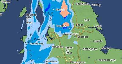
Monday looks to be a largely cloudy day with an increasing chance of showery rain and drizzle developing. We can expect some mist and hill fog, with temperatures feeling chilly at a maximum of 5C.
Into the evening forecasters say we will see cloudy weather with further outbreaks of patchy light rain and drizzle. However, temperatures will stay a little higher than during recent nights, with highs of 2C, keeping most places frost-free.
Similarly to Monday, Tuesday is set to remain cloudy with outbreaks of drizzle. Maximum temperature of 5C.
We could see a misty start on Wednesday morning, but this is set to clear by around 9am.
Forecasters predict a slightly warmer temperature of 6C, but say it will feel chilly, with frost and fog possible overnight.
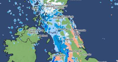
Conditions will turn 'increasingly unsettled' from Thursday, according to the Met Office, with chances of gales and heavy rain. Temperatures
Related News