Met Office weather maps show exactly when and where snow will fall as Storm Éowyn hits
Storm Éowyn is forecast to bring heavy snow to some parts of the UK this week.
The fifth named storm of the season is currently forming over the Atlantic and is set to batter the UK with strong winds from Thursday night. The Met Office has warned that some areas could see wind gusts of more than 80mph.
The storm could cause power cuts, travel disruption, damage to buildings and injuries from flying debris, forecasters have warned.
The Met Office has issued yellow wind warnings from midnight on Friday covering most of the UK, including the south-west of England, the Midlands, northern England, Northern Ireland and Scotland. The weather agency issued an additional warning from midnight on Saturday to late afternoon that day across Scotland and the far north of England.
While the biggest impacts are likely to be from the strong winds and heavy rainfall, the Met Office has predicted snow across some areas of the UK as the storm hits.
Met Office spokeswoman Andrea Bishop said: “Storm Eowyn will bring a period of very unsettled, potentially disruptive, weather to the UK through Friday and into Saturday. Pronounced ‘Ay-oh-win’, the system will begin to influence the UK’s weather on Friday, with strengthening winds initially in north-western parts of the UK with accompanying heavy rainfall.”
The change to conditions is being caused by a powerful jet stream pushing low pressure across the Atlantic and towards the UK, following a recent cold spell over North America, the Met Office said.
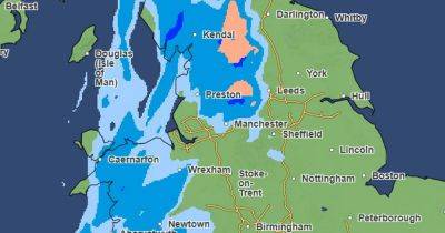
The Manchester Evening News has taken a look at the Met Office's weather maps for the next few days, which pinpoint when and where snow is likely to fall.
The Met Office says the UK will see "a major change" in the weather from Thursday as
Related News