'Act now' Storm Bert flood warnings as River Irwell bursts banks and residents call for sandbags
The River Irwell in Ramsbottom, near Bury, has reportedly burst its banks as Storm Bert continues to bring heavy rain and lashing winds to the region.
Images show large areas of Nuttall Park in Ramsbottom under water, with flooded roads also captured in images being shared on social media. Flooding is also being reported in the Stubbins area.
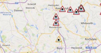
A number of urgent Environment Agency 'act now' flood warnings are in place in the surrounding areas. They warn: "Rising river levels are expected to cause flooding from now until daybreak Sunday 24 November 2024."
READ MORE: LIVE UK weather: Storm Bert brings snow, wind, rain and flooding to Greater Manchester - latest updates
The warning areas cover the River Irwell at Bacup and the River Irwell at Irwell Vale. "Flooding is forecast to affect locations near the River Irwell, with low lying land and roads expected to be most affected, particularly around Irwell Vale, Aitken Street, Bowker Street, Chapel Terrace, Hardsough Fold, Milne Street and Parkinson Fold," reads the Environment Agency warning for the Irwell Vale area.
"Start acting on your flood plan if you have one. Take care and avoid walking, cycling or driving through flood water."
A third warning also covers the Irwell at Rawtenstall.
Properties on and adjacent to Burnley Road; south of Constable Lee Bridge; Bocholt Way and Bacup Road, from Bury Road to Lench Road; properties near Hareholme Mill, Victoria Works and Holme Lane, including parts of New Hall Hey Road, are covered.
A fourth warning covers the Irwell at Summerseat. "Areas at risk include land and properties alongside the river at Summerseat, including some properties on Waterside Road, Riverside Drive and The Island," said the Environment Agency.
Areas
Related News